Francigena Ultra Marathon Percorso
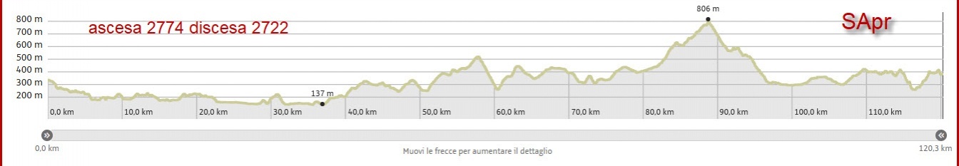
Challenging route for both the mileage and the elevation gain that requires adequate preparation.
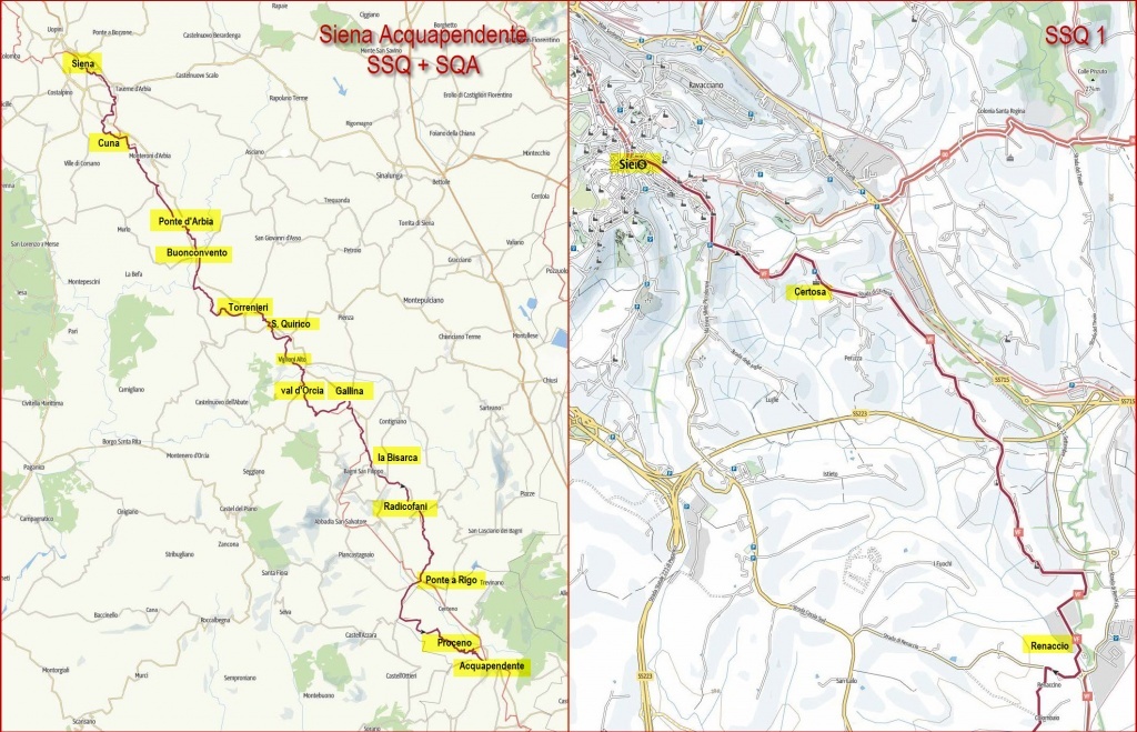
From Siena, after crossing the center, you arrive at Porta Romana and you go down in a south-easterly direction on asphalt and then on a dirt road until the Certosa di Maggiano (km 2.17) and continue slightly downhill until the area of Ruffolo where you pass over the SS 223 of Paganico (km 4.37).
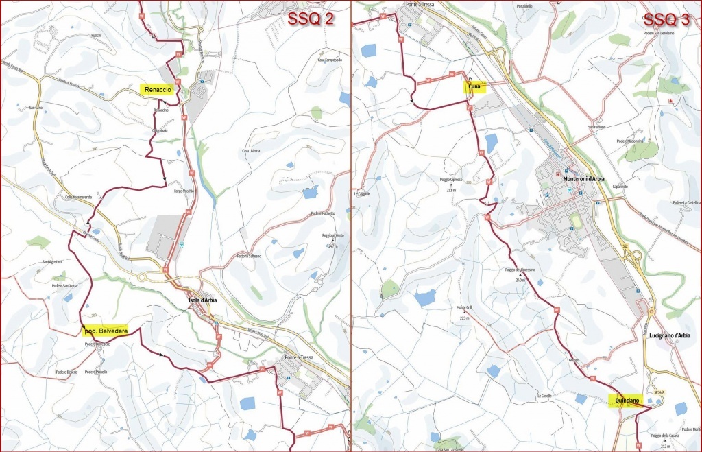
Continue along the Certosa road and pass a traffic circle (km 6.9). At km 8.6 you have to turn right on the road of Borgo Vecchio and you’re near the industrial area of Siena, you cross the Cassia near the hill Malamerenda (km 9.7) and here you take the path originally traced by the Tuscany Region that leads to the dirt road of Radi; you follow it for a while and then turn left (farm Belvedere km 12) going slightly up the hill through a succession of farms and cultivated fields. On the left there is the tower of tomatoes, a cylindrical concrete structure 50 meters high, built in the 60’s for the freeze-drying of tomatoes and never entered into operation. The tower is visible from miles away and has become an element of the landscape.
We approach Ponte a Tressa (km 15) until we reach the Grancia di Cuna at km 16.8. The Grancia is an ancient fortified granary owned by Santa Maria della Scala, currently under renovation. It remains on the left of the route that continues in a southerly direction.
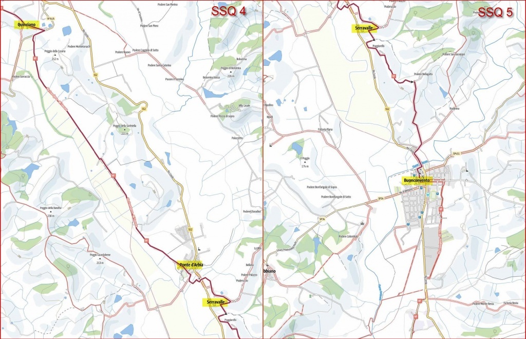
After the town of Monteroni (km 18.4), the route continues halfway up the hill among hills cultivated with wheat, passes the Poggio del Cipressino at km 19.7 and arrives in Quinciano (km 21.9). After Quinciano, you have to ride along the provincial road 34 for a short stretch and then you have to cross it to get onto a dirt road (km 22.5) that runs along the railway line, first on the right and then on the left. It goes through farms and chianina cattle breeding and arrives in Ponte d’Arbia (km 27.6).
You cross the Arbia river on the new wooden pedestrian bridge (km 28) and then you cross the Cassia road. After a few ups and downs (between the areas of Serravalle and Poggiarello) you’ll reach the crest (km 30.9) with the Arbia valley (and the Cassia) on the right and, on the left, beyond the Ombrone river, beautiful views of the Crete area (up to the abbey of Monte Oliveto Maggiore).
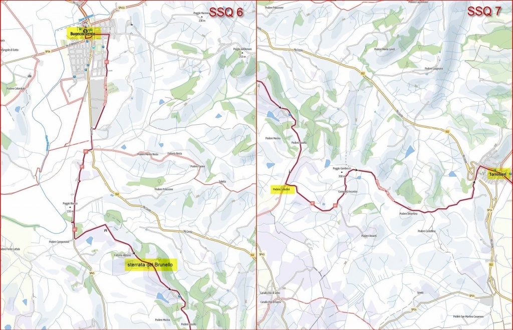
When you reach the cemetery of Buonconvento, go downhill (km 32.1) and, after a stretch along the edge of the Cassia, crossing the Ombrone just before its confluence with the Arbia, you’ll skirt the town, entering through the northern gate and following the central road. It is advisable to take advantage of the refreshments with hot dishes before embarking on the second part of the route.
We cross the Cassia again and we go slightly upstream crossing the area of the sports facilities and craft activities. You have to go down along a concrete ramp and at km 35.1 you have to cross again the Cassia road for a few meters and at the fork you have to take the provincial road on the right towards Montalcino, walking on a path along the road (km 35.5). We leave it at a point where the Ombrone river, which is on our right, makes a sharp U-turn and we ford a small ditch that acts as a border between Buonconvento and Montalcino (torrent Serlate km 36.9).
We proceed for a hundred meters at the edge of the road and then we turn left (km 37.2) and we start a long stretch of dirt road (almost 10 km) in the middle of the hills of Brunello (among vineyards and cultivated fields) passing through the farms Castello Tricerchi, Altesino (km 38.5), Casella and arrived at the church of San Sebastiano we turn left at the farm Collodini (km 41.3).
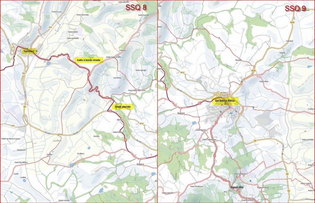
We pass Podere Viti, the Incontro community and Podere Desertino (44.5 km) until we reach Torrenieri (a hamlet of Montalcino) at km 46.2. After leaving Torrenieri begins a stretch of a couple of km in which you have to ride on a path along the road (in some point directly on the road). Keep right at the crossroads at km 49.1 until you leave the paved road and abruptly turn right at km 50.7 in correspondence of a large gas station.
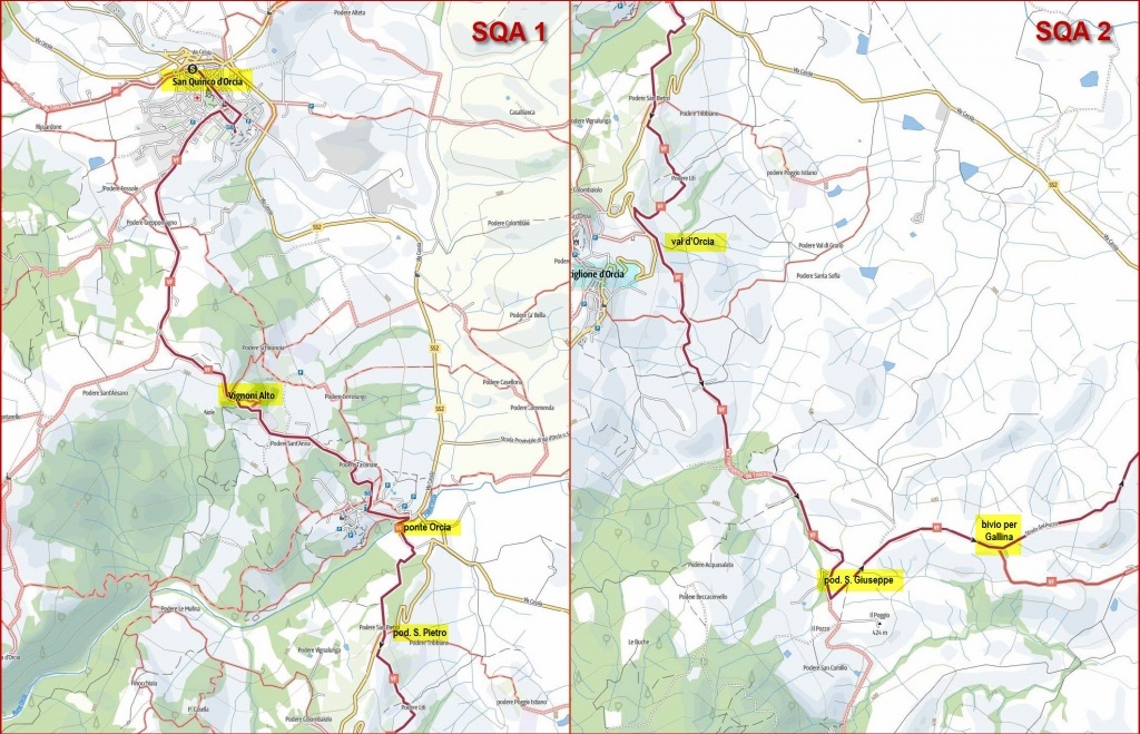
You pass under the Cassia (km 51) and the dirt road continues having on both sides farms with stretches of forest until you reach, with a small final stretch (km 54), San Quirico d’Orcia.
We leave the village in a southerly direction and take the road to Ripa d’Orcia, turning left at the crossroads at 57.1 km. We continue until the ancient village of Vignoni Alto (km 57.85). You don’t cross the village, but you go around it from the right, you pass the cemetery of Vignoni, you pass through the farm Tassinaie (km 59.1) until you reach Bagno Vignoni (km 60).
You don’t enter the village, but you have to turn left downhill and at km 59.8 you leave the road of Bagno Vignoni bending right with a U-turn to go down towards the Orcia river that you cross on a wooden footbridge built at a point where the valley narrows (km 60.1).
*** The pedestrian bridge over the Orcia has had the base of one of the pylons slightly damaged and procedures to make it safe are still in progress. At the date of opening of entries it is not yet possible to establish with certainty the route to overcome the Orcia also because the alternative passage along the Cassia, has problems of safety **.
At km 60.7 you ignore the detour to the left that leads to the Cassia, you continue straight, you pass through the farm San Pietro (km 61.6) ignoring the road that leads to the Rocca d’Orcia and Castiglion d’Orcia.
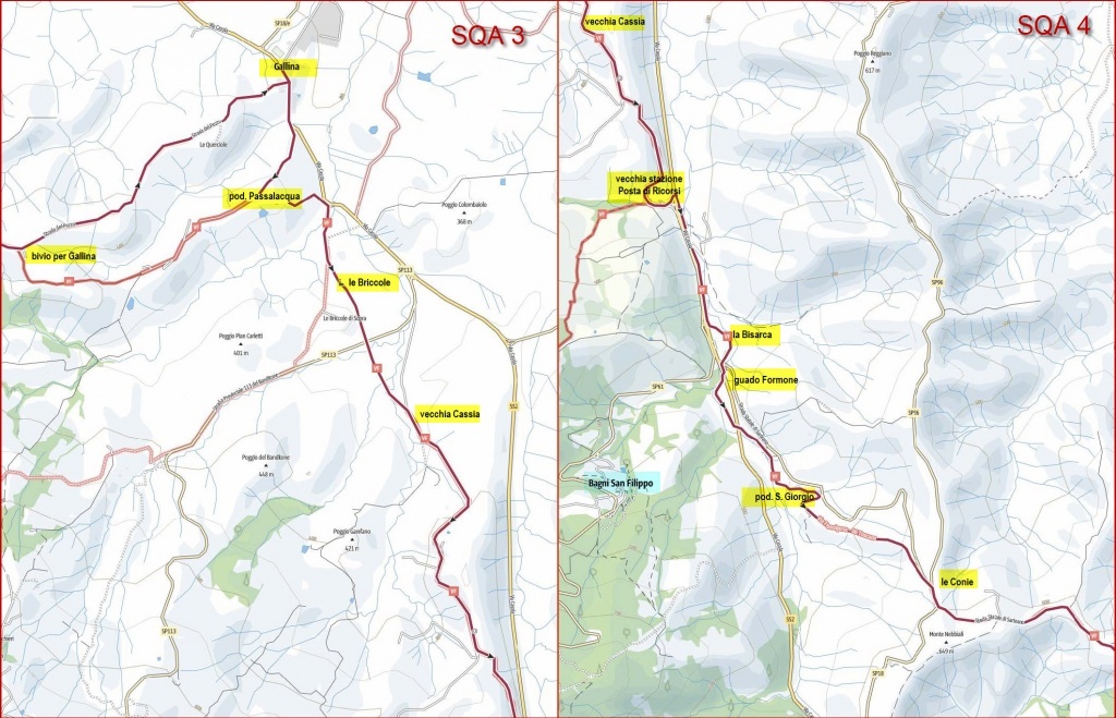
It skirts the area of Rocca d’Orcia (km 61.84) and Castiglion d’Orcia from below and then follows a stretch through the cultivated areas of the Val d’Orcia, mostly on dirt road. We pass through the farm San Giuseppe, Acqua Salsa and keep left at the junction (km 68.24) taking the Strada del Pozzo that leads us to the Cassia near the village of Gallina (km 71). Go up the Cassia on the left for 200 meters until you reach the village and the refreshment point (km 71.2).
We retrace the stretch of Cassia and we leave it (km 71.7) bending slightly to the right and, arrived at the farm Passalacqua (km 72.5), we turn sharply left, we approach the Cassia again, we cross the river Vellora (km 73.2) and continue until the church of Briccole (old hospice) at km 73.8.
At km 74.2 you cross the provincial road of Banditone and continue by passing a series of small fords and at km 75 you get on the road following the old route of the Cassia for a few km until you reach the old post station of Ricorsi near the new route of the Cassia. (km 78.6, altitude 412).
At the old post office of Ricorsi (km 78.7) cross the Cassia (pay attention) and take a small road that runs parallel to the Cassia, with the Cassia on the right and the Formone torrent on the left. At La Bisarca (km 79.7) the route bends slightly to the left, approaching the stream that forms a bend and then you have to go under a viaduct (SP 478 to Radicofani) and you have to cross the stream (km 80.3).
You pass under the Cassia and you ride along the stream for a while until you pass under the Cassia again (km 80.9) and you continue along the stream until the farm San Giorgio (km 81.6) where you turn left approaching the SP 478 (km 81.9). At that point you have to turn right, instead of accessing the provincial road to Radicofani, and take the old dirt road of the Cassia.
It continues to climb until it meets again the provincial road for Radicofani at the point where the SP for Contigiano starts (locality Le Conie km 83.5 altitude 590). We follow the provincial road to Radicofani passing the junction of the SP 18 of Monte Amiata and continue along the road to Radicofani leaving it at km 85.9 (665 m) where we turn right.
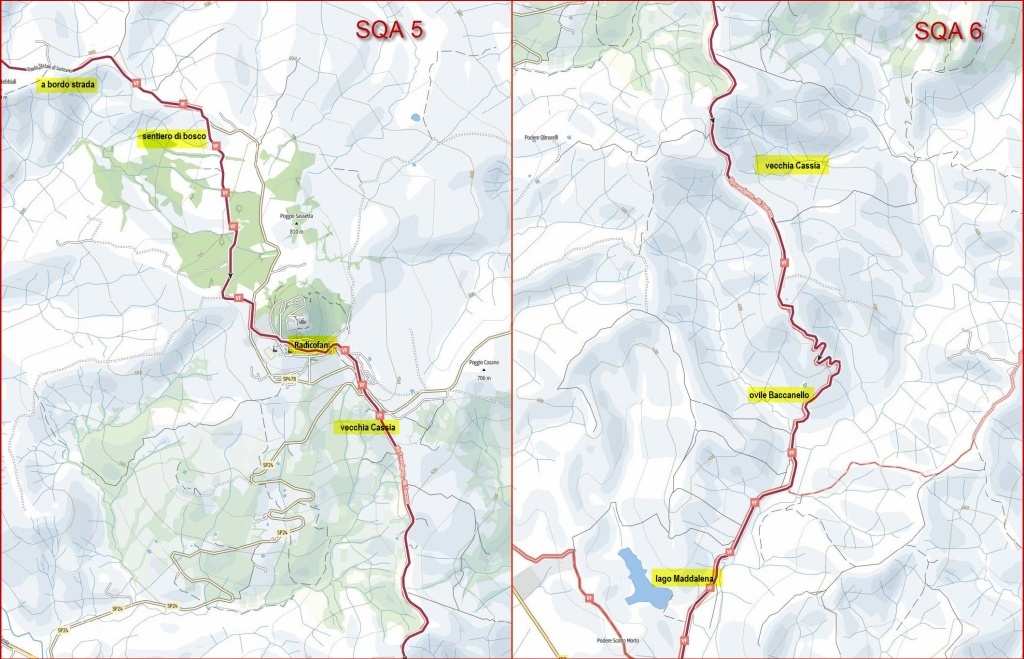
We continue to climb on a dirt road until km 87.7 (760 m) where we turn left and we go back on the road to Radicofani now near the village. Follow the road for about 500 m and then leave it to turn left and enter the village along the central Via Roma (km 88.7).
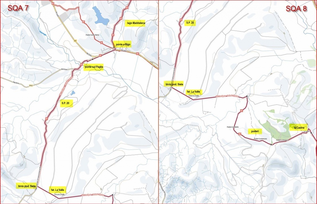
The stretch from Radicofani to Ponte a Rigo, all on dirt road, follows, in the north-southeast direction, the path of the ancient Via Cassia (which passed through Radicofani). It takes place on a very suggestive route made of pastures for sheep (once much more frequented) crossed by gullies while, behind, dominates the fortress of Radicofani. On the left ridge, in the distance you can see the structure of the astronomical observatory.
From the center of Radicofani, you go along the via Roma, you exit from the door and you follow a stretch of the SP 24, you pass the branch for the SP 478 (Sarteano) and shortly after, in correspondence of a hairpin bend (km 89.4), you leave the SP 24 and you take the old Cassia dirt and downhill that joined Radicofani and Ponte a Rigo (with a path of about) 9 km.
You ignore the many detours to the right and left that lead to old farms and, after some hairpin bends that allow you to mitigate the slope, you arrive at the sheepfold of Baccanello (km 96 altitude 363 m) and you meet on the left the Rigo torrent.
After passing a rural village, the road begins to level out. At km 98.5 you can see on the right the Maddalena lake and, immediately after, you arrive at Ponte a Rigo (km 99), intersection point with the route of the stretch Abbadia San Salvatore Acquapendente.
At Ponte a Rigo (hostel and refreshment point) you go down to the Cassia, you ride along it on the right until a crosswalk near a bar tobacconist, you cross the Cassia and you go down to the Rigo river bed (km 99.1). We bend to the right and ride along the Cassia from underneath, walking on a path on the edge of the field for about 500 meters and after leaving the Cassia and going straight ahead we bend to the right to leave the path to go up to the SP 20 (crossroad Cassa Aurelia) that we will ride for a few kilometers (km 99.9).
We cross the Paglia river on a bridge and immediately after we leave the SP 18 on the right and continue left on the SP 20 (km 100.5). We follow the provincial road until Podere Siete (km 104.2) where we take a dirt road on the left until the farm La Valle (km 104.9). Here we turn sharp left, we cross the river Siele at km 106.3 and immediately after, at the fork we turn right.
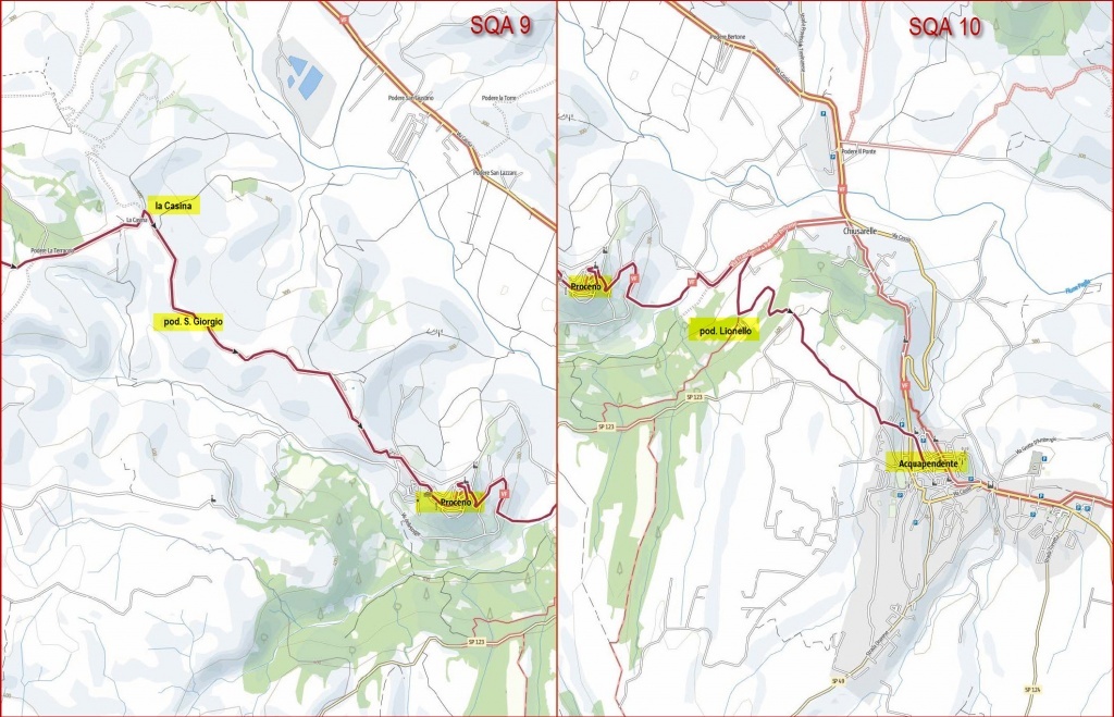
With a non-linear route (proceeding east-southeast) you pass a series of farms Cornietello (km 107.6), Sant’Antonio (km 108.4), La Terraccia (km 109.3), La Casina (km 110.1). Here you have to turn right and you arrive at the farm San Giorgio (km 111.3) and from there (in SE direction) you arrive at Proceno (km 114.2).
You pass the town and proceed along the provincial road Proceno until you reach the Cassia (km 116.2), turn right (km 116.6), pass the farm Lionello (km 117.2) and soon you reach Acquapendente where the route ends in Piazza del Comune (km 120).
Register your arrival, collect the certificate of participation and enjoy the rich hot refreshments.